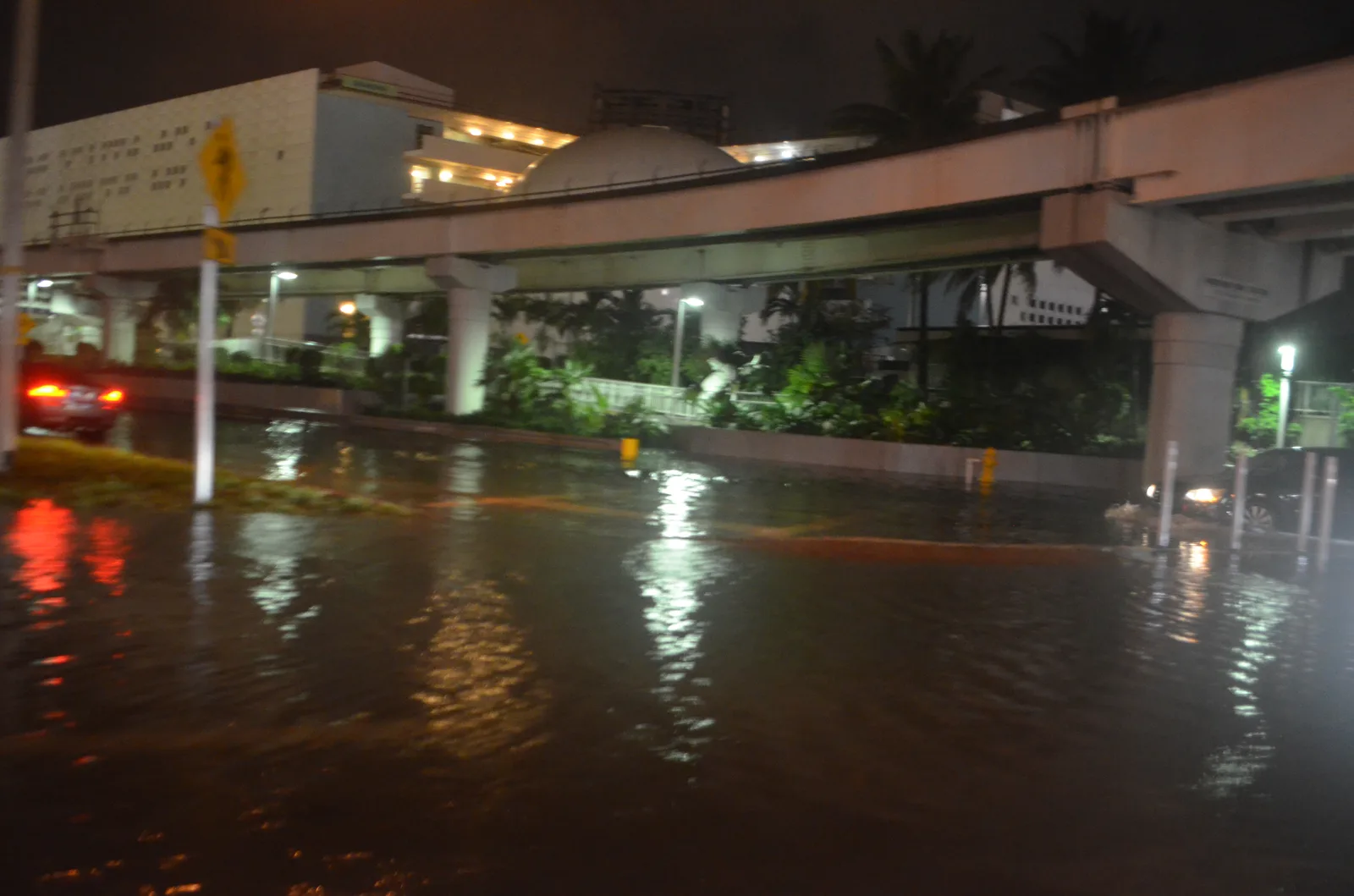
Middle River hit 2.83 feet Tuesday and Wednesday, past major flood stage. A coastal flood advisory runs to 8 p.m. Saturday; the next king tides are Nov. 5-11.
The king tides that start Saturday could push water in Fort Lauderdale to record heights, the city said. It expects widespread tidal flooding on roads through Oct. 31.
The morning tide at about 9:45 a.m. Tuesday, Oct. 27, should be the highest of the year. The city said wind, currents and sea level rise could drive tides to “potential record elevations.” Rain before or during a peak tide will make the ponding worse. That comes from the city’s higher tides notice for Oct. 24-31.
Updated Oct. 30: the coastal flood warning ended at 8 p.m. Wednesday, Oct. 28, after the weather service extended it a day. All three Fort Lauderdale gauges passed the 2.5-foot major flood stage. The Middle River gauge at Sunrise Boulevard peaked at 2.83 feet at 10:06 a.m. Tuesday and again at 10:54 a.m. Wednesday, according to NOAA’s preliminary readings. A coastal flood advisory runs until 8 p.m. Saturday, Oct. 31. The city lists the next king tides as Nov. 5-11 and Nov. 22-28. Full readings are in our coastal flood story.
Updated Oct. 25: the National Weather Service in Miami upgraded to a coastal flood warning for coastal Broward County from 2 a.m. Monday to 8 p.m. Tuesday, with major flood stage expected both days. The Middle River gauge at Sunrise Boulevard passed major flood stage at 8:30 a.m. Sunday, at 2.51 feet. Details in our coastal flood warning story.
The weather service advisory, now a warning
The National Weather Service in Miami issued a coastal flood advisory for coastal Broward County at 3:54 p.m. Thursday. It warns of moderate coastal flooding until 8 p.m. Saturday: flooded lots, parks and roads, with isolated road closures.
The weather service said the advisory will either be extended into next week or upgraded to a warning Sunday into Monday. That is when the king tides peak and rain chances and onshore winds are highest.
On Sunday morning it issued the coastal flood warning, from 2 a.m. Monday to 8 p.m. Tuesday. It warns that numerous roads may be closed and low-lying homes and businesses will be flooded. A high rip current risk runs through late Tuesday night, and the weather service expects advisories through much of the week after that.
The forecast for Fort Lauderdale shows why:
- Saturday: showers and thunderstorms likely, 60% chance, northeast wind gusting to 26 mph
- Sunday: showers and thunderstorms, 90% chance, gusts to 35 mph
- Monday: showers and thunderstorms, 80% chance, gusts to 37 mph
The water is already high
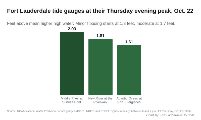
Two Fort Lauderdale river gauges reached moderate flood stage on Thursday evening, before the king tide window opens. The readings are from the NOAA National Water Prediction Service:
- Middle River at George English Park, Sunrise Boulevard: 2.03 feet at 6:30 p.m.
- New River at the Riverwalk: 1.81 feet at 6:36 p.m.
- Atlantic Ocean at South Port Everglades: 1.61 feet at 6:06 p.m.
Heights are measured above mean higher high water. At all three gauges, minor flooding starts at 1.3 feet, moderate at 1.7 feet and major at 2.5 feet.
When the tides peak
The city published these peak times. Water is highest for an hour or two either side of them.
| Day | Morning peak | Evening peak |
|---|---|---|
| Saturday, Oct. 24 | 7:15 a.m. | 7:30 p.m. |
| Sunday, Oct. 25 | 8 a.m. | 8:15 p.m. |
| Monday, Oct. 26 | 8:45 a.m. | 9 p.m. |
| Tuesday, Oct. 27 | 9:45 a.m. | 9:45 p.m. |
| Wednesday, Oct. 28 | 10:30 a.m. | 10:30 p.m. |
| Thursday, Oct. 29 | 11:15 a.m. | 11:30 p.m. |
| Friday, Oct. 30 | 12:15 p.m. | None listed |
| Saturday, Oct. 31 | 12:30 a.m. and 1:15 p.m. | None listed |
What it means for you
- Plan the morning commute around the peaks. Monday through Wednesday, the highest water lands between 8:45 and 10:30 a.m., right in the rush.
- Do not drive through standing water. Road closures for tidal flooding are possible, the city said. Drive slowly near flooded streets so your wake does not push water toward homes.
- Protect your property. If wakes reach your street, the city suggests sandbags at entry points and raising belongings off the floor. The city’s free sandbag weekends at local parks run on the third Saturday and Sunday of each month through November, according to its king tides page. This month’s fell on Oct. 17-18.
- Hold your trash carts. If your street floods, keep carts off the curb, or bring them back in right after pickup, so they do not tip, fill with water or float into the road. Our trash and recycling page has the pickup schedule.
- Report an impassable street to the city at 954-828-8000, by email to cservice@fortlauderdale.gov or through FixIt FTL.
The neighborhoods where the city is working on tidal flooding are listed on our king tides page from earlier this month. For street closures that are not about the tide, see road construction and closures. Our hurricane prep guide covers flood zones and flood insurance.
Have your say